08 9322 1430 info@middleisland.com.au

Barkly Copper Gold Project
Barkly Copper Gold Project
Northern Territory Back to Project

Middle Island Resources Limited’s Barkly super-project comprises of 11 exploration licence granted applications covering 4,343.49 square kilometres and 5 pending applications covering 1,190.10 square kilometres as shown in Figure 1 below, within the Barkly region of the Northern Territory (NT). The applications semi-continuously extend for over 350km along the axis of the fault-bounded East Tennant Ridge from Tennant Creek, east across the Barkly Tableland, towards the Queensland border near Mt Isa.
This strategy positions the Company as a first-mover within the newly identified, iron oxide-copper-gold (IOCG)-prospective, East Tennant area, which extends across the Barkly Tableland. The tenement applications will collectively comprise the ‘Barkly Copper-Gold Super Project’.
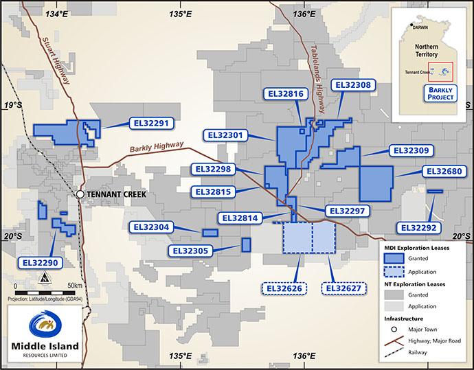
Figure 1. Middle Island’s accepted and allocated tenement applications comprising the Barkly super-project, Northern Territory.
Collaborative Geoscience Australia (GA) and Northern Territory Geological Survey (NTGS) research has identified the East Tennant region as a priority area to host IOCG mineralisation.
Setting
To the north and east of the Georgina Basin, the Proterozoic Mount Isa Inlier in northwest Queensland is recognised as a world-class mineral province, hosting an estimated 75% of the State’s total copper, lead, zinc and silver resources. The majority of the Mount Isa Inlier is interpreted to lie beneath Georgina Basin cover, and is prospective for IOCG deposits, sedimentary exhalative (Sedex) Zn-Pb-Ag deposits, and structurally controlled Cu+/-Au deposits. The Sedex deposits of Mount Isa collectively contain 90Mt of combined Pb-Zn metal, plus 300Mt of ore grading 2.8% Cu, and silver at grades of up to 150g/t Ag. The Mount Isa, George Fisher and Century Sedex deposits, are the largest examples of their type in the world.
To the west of the Georgina Basin, the Tennant Creek Block in the central Northern Territory hosts high grade Proterozoic gold and copper-gold deposits and mines associated with magnetite-haematite-rich ironstones of IOCG affinity. These deposits are generally structurally controlled and tend to align within a number of distinct mineralised corridors.
The disposition of Middle Island’s tenement applications relative to deposits surrounding the Georgina Basin is shown in Figure 2 below.
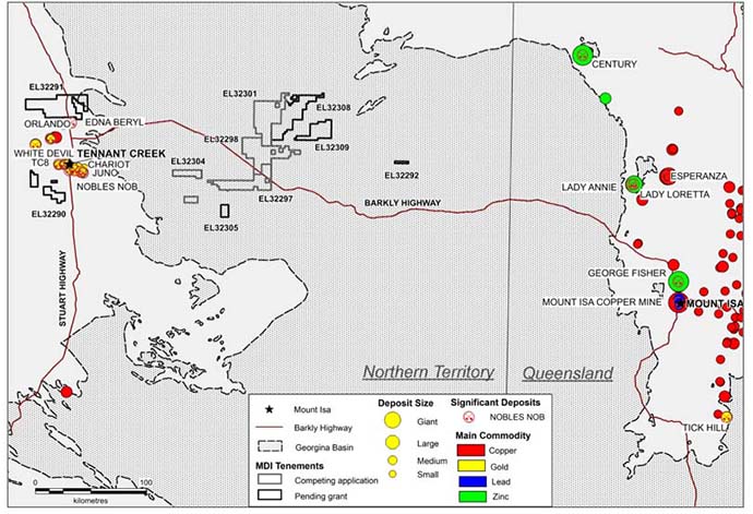
Figure 2. Middle Island applications relative to major deposits peripheral to the Georgina Basin.
Background
Middle Island identified the Barkly Tableland region, east of Tennant Creek, as an extensive area of unexplored basement potential. Assessment of Exploring for the Future (EFTF) data sets, integrated with historic open file data, led to the identification of several priority targets of interpreted IOCG affinity, extending beneath sedimentary cover along a sinuous, fault-bounded corridor from Tennant Creek to Mount Isa.
Middle Island’s early focus on the East Tennant area afforded the Company the opportunity to confirm priority targets prior to the public release of GA and NTGS pre-competitive research data, and to be well-positioned when the exploration licence moratorium was lifted on 7 October 2019.
In addition to competition from Rio Tinto Exploration in the more immediate Tennant Creek area, five of Middle Island’s applications surround or adjoin Newcrest Mining applications along the axis of the East Tennant Ridge in the Barkly area, further justifying the strategy and target selection rationale.
Exploring for the Future Initiative
The East Tennant Province has been the focus of several comprehensive completed and on-going pre-competitive studies by GA and NTGS in recent years, and is rapidly gaining attention as a priority, yet largely unexplored, IOCG mineral province.
Interest in the East Tennant area has grown significantly since it was selected as one of the focus areas for the four-year EFTF program, a $100.5 million initiative by the Australian Government dedicated to boosting investment in Australian mineral exploration.
As a result of the EFTF initiative, the Tennant Creek to Mount Isa region is now one of the most heavily researched and best-imaged lithospheric terranes in the world, with multiple geophysical datasets, surface and down-hole geochemistry, solid geology interpretations, isotopic mapping, isometric cover thickness models and U-Pb geochronology.
The first quarter of 2019 saw the release of data from the Australian Airborne Electro-Magnetic (AusAEM) survey, the world’s largest of its type, extending over east and central Northern Territory and western Queensland. This survey was conducted as a collaboration between GA, NTGS and the Geological Survey of Queensland (GSQ).
The datasets also include the Australian Lithospheric Architecture Magneto-telluric Project (AusLAMP) to model lithospheric conductivity. Data is collected using a passive geophysical technique that measures the Earth’s electric and magnetic fields to determine the conductivity/resistivity of the subsurface in three dimensions. The data is processed to produce a model of the conductivity of the earth from ten to hundreds of kilometres depth, through the crust and upper mantle.
In addition to the AusAEM and AusLAMP surveys, the relevant pre-competitive data comprises airborne magnetic, gravity and seismic surveys, and geochemical and stratigraphic drilling programs specific to the East Tennant area. Preliminary findings of this work were released at an industry seminar in Perth in September 2019, with notable conclusions highlighting the IOCG prospectivity of the East Tennant region in particular (termed the East Tennant Ridge), including:-
- Large-scale and deep-seated structural architecture.
- High conductivities modelled to extend from the mantle.
- Modelled iron-oxide alteration.
- Modelled mineral potential.
- Accessible basement depths.
All datasets were utilised by GA to generate an IOCG prospectivity map, shown in Figure 3 below.
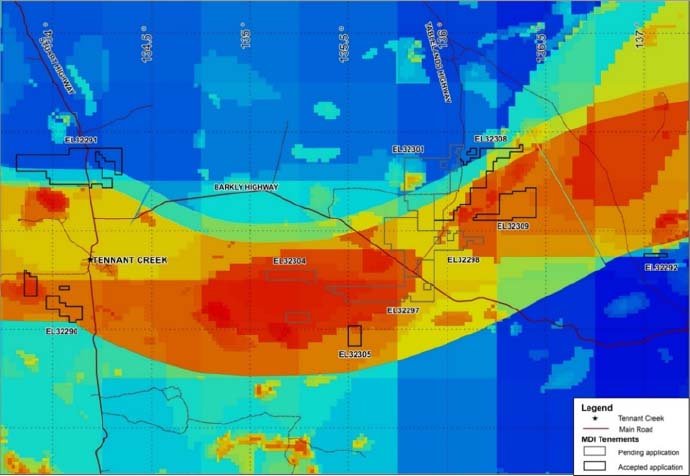
Figure 3. Middle Island applications relative to the GA IOCG prospectivity mapping (hot colours being most prospective).
Several studies are on-going, including stratigraphic and geochemical basement drilling, and further deep crustal seismic traverses, with final results expected in 2020.
Significant outcomes from the work completed and analysed to date are the projected shallow depth to mantle, coincident with the shallow sedimentary cover along the East Tennant Ridge, and the modelled IOCG mineral potential. These findings establish linkages between the mantle as a fluid, heat and mineral source, and northeast-southwest trending crustal-scale faults, associated with the East Tennant Ridge, that act as fluid pathways to bring metal concentrations close to the surface.
The third outcome of work carried out by GA, was to predict and map the presence of IOCG-related alteration using 3D magnetic susceptibility and density models, produced by inverting gravity and magnetic intensity data sets. These inversion models provide an indication of the volume and distribution of these physical properties within the earth. Volumes with relatively high densities and magnetic susceptibilities were treated as proxies for magnetite-rich alteration, and volumes with high density and low magnetic susceptibility were treated as proxies for haematite-rich alteration, as shown in Figure 5 below.
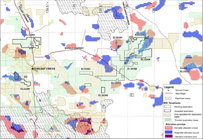
Figure 4. Middle Island applications relative to hematite and magnetite alteration proxies, potentially associated with mineralised IOCG systems.
It is within such alteration zones, particularly at the interface between the two, that copper, gold, uranium and rare earth element mineralisation, consistent with the IOCG model, may be present. However, the inversion modelling will also inevitably identify a number of false-positives, requiring more detailed datasets and/or inversion modelling to enable discrimination from true IOCG-related alteration.
Exploration Opportunity
The Barkly tenement applications are focused on an interpreted eastward extension of the fault-bounded and economically prospective East Tennant Ridge under shallow Georgina Basin cover. This model is consistent with major recent mineral discoveries in basement rocks reported from ‘blind’ targets veneered by younger sedimentary cover in WA’s Paterson Province (Winu and Havieron) and extensions of the prolific Victorian gold belts under Murray Basin sedimentary cover (Four Eagles and Tandarra). These regional examples were, at least in part, similarly generated as a result of extensive, collaborative, government research projects.
Significant examples of ‘blind’ IOCG deposits discovered beneath substantial sedimentary cover include BHP’s Olympic Dam and Oak Dam deposits and Oz Minerals’ Prominent Hill and Carapateena deposits in South Australia, which are variously overlain by up to 900m of post-mineral sedimentary cover.
The Georgina Basin extends east from Tennant Creek across the Queensland border to Mount Isa, and is subdivided by several basement highs into smaller sub-basins. The principal basement high, the East Tennant Ridge, runs northeast under the Barkly Project area, where the interpreted depth of cover ranges from 100m to 250m along the ridge axis, increasing to ~800m on the flanks of the ridge.
The East Tennant Ridge is of particular significance in that, aside from phosphate exploration within the overlying Georgina Basin, previous exploration activity within the Proterozoic basement rocks is essentially non-existent.
This strategy positions Middle Island as a first-mover within the newly identified, fault-bounded, East Tennant province, which is highly prospective for Tier 1 IOCG targets, extending beneath Georgina Basin cover across the Barkly Tableland.
Project details
Title
Barkly Copper Gold Project
Location
Northern Territory
Perfomance
Fact sheet

- Suite 1, 2 Richardson Street
West Perth WA 6005 - +61 8 9322 1430
- +61 8 9322 1474
- info@middleisland.com.au